


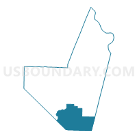
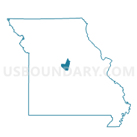
High Point Voting District, Moniteau County, Missouri
About
Outline

Summary
| Unique Area Identifier | 609157 |
| Name | High Point Voting District |
| County | Moniteau County |
| State | Missouri |
| Area (square miles) | 51.67 |
| Land Area (square miles) | 51.41 |
| Water Area (square miles) | 0.26 |
| % of Land Area | 99.50 |
| % of Water Area | 0.50 |
| Latitude of the Internal Point | 38.47553540 |
| Longtitude of the Internal Point | -92.57767300 |
Maps

Graphs
Select a template below for downloading or customizing gragh for High Point Voting District, Moniteau County, Missouri


Neighbors
Neighoring Voting District (by Name) Neighboring Voting District on the Map
- Barnett I Voting District, Morgan County, MO
- Eldon Rural Voting District, Miller County, MO
- Excelsior Voting District, Morgan County, MO
- Harmony Voting District, Moniteau County, MO
- Latham Voting District, Moniteau County, MO
- Olean Voting District, Miller County, MO
- Russellville Voting District, Cole County, MO
Top 10 Neighboring County Subdivision (by Population) Neighboring County Subdivision on the Map
- Saline township, Miller County, MO (8,315)
- Moreau township, Morgan County, MO (5,854)
- Moreau township, Cole County, MO (2,786)
- Pilot Grove township, Moniteau County, MO (1,275)
- Harrison township, Moniteau County, MO (752)
- Burris Fork township, Moniteau County, MO (700)
Top 10 Neighboring Elementary School District (by Population) Neighboring Elementary School District on the Map
Top 10 Neighboring Unified School District (by Population) Neighboring Unified School District on the Map
- Eldon R-I School District, MO (12,072)
- Morgan County R-II School District, MO (11,110)
- Cole County R-I School District, MO (3,990)
Top 10 Neighboring State Legislative District Lower Chamber (by Population) Neighboring State Legislative District Lower Chamber on the Map
Top 10 Neighboring State Legislative District Upper Chamber (by Population) Neighboring State Legislative District Upper Chamber on the Map
Top 10 Neighboring 111th Congressional District (by Population) Neighboring 111th Congressional District on the Map
Top 10 Neighboring Census Tract (by Population) Neighboring Census Tract on the Map
- Census Tract 4701, Morgan County, MO (6,046)
- Census Tract 9626, Miller County, MO (3,581)
- Census Tract 3853, Moniteau County, MO (3,460)
- Census Tract 205, Cole County, MO (2,786)
Top 10 Neighboring 5-Digit ZIP Code Tabulation Area (by Population) Neighboring 5-Digit ZIP Code Tabulation Area on the Map
- 65026, MO (11,551)
- 65018, MO (7,714)
- 65084, MO (6,797)
- 65074, MO (3,061)
- 65011, MO (2,374)
- 65050, MO (755)
- 65064, MO (578)